The EU FLEGT and Action against deforestation initiatives
FLEGT - for "Forest Law Enforcement Governance and Trade" - is a European Union action plan to fight illegal timber trafficking. Launched in 2003, its aim is to prevent any illegal timber from entering the European Union by certifying the origin of imported timber under "Voluntary Partnership Agreements" (VPAs) in order to combat illegal logging.
EU Communication (2019) on Stepping Up EU Action to Protect and Restore the World’s Forests provides an important new commitment of the European Union to stamp out deforestation from supply chains of agricultural commodities imported. The Communication aims to protect and improve the health of existing forests, especially primary forests, and to significantly increase sustainable and biodiverse forest cover worldwide.
The ability to monitoring of forests and traceability of commodity supply chains will be priorities. Actions will seek to establish an EU Observatory and seek to establish a Copernicus REDD+ service component.
Introducing FLEGT Watch
FLEGT Watch Web is an application that automatically detects changes in forest cover from satellite data. When a deforestation event is detected in a monitored area, FLEGT Watch Web warns the observers in that area. They can comment on the event and decide to go and check the reality on the field with a mobile FLEGT Watch App for smartphones that allows them to organize field missions, collect in-situ observations and share them with the community. These observations are used to automatically edit field mission reports. Developed during the year 2018 according to the user specifications of CIDT and Tropenbos International, FLEGT Watch is operational since January 1st, 2019.
Actors
The system was designed primarily for independent observers, individuals from civil society, such as members of non-governmental organizations (NGOs), associations, village communities...
When they receive deforestation alerts in monitored areas, they can check on the ground and assign observers. All the independent observers around the same monitored area form a community to which the detected changes are addressed.
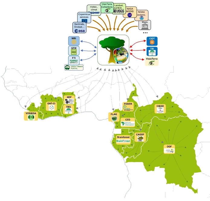
In its first version, FLEGT Watch covers two sub-regions each led by two Project Managers : -Central Africa (Cameroon, Gabon, Republic of Congo, Democratic Republic of Congo, Central African Republic) supervised by CIDT and -West Africa (Liberia, Ivory Coast, Ghana) supervised by Tropenbos International.
In each country, the Project Manager of the sub-region has designated one or more national officer(s), each responsible for an NGO and coordinates the training and in-situ support plans.
Fig. 1 - Organization of FLEGT Watch and its actors.
FLEGT Watch in action
One of the main qualities of FLEGT Watch is to be able to report deforestation in near real time, i.e. within seconds of satellite data being made available by space agencies (mainly the European Space Agency for Sentinel data).
FLEGT Watch operates primarily in tropical regions with heavy cloud cover and uses primarily Sentinel-1 radar satellite imagery. Each new radar acquisition is compared to the previous 4 acquisitions taking into account topographic features, weather data and recent precipitation. An algorithm detects significant changes by attaching a three-level confidence index to them.
Fig. 2- Example of deforestation detected by FLEGT Watch (in yellow), in the northeast of the Democratic Republic of Congo. (hyperlook)
Events detected in a monitored area are accessible to all members of the independent observer community around the concerned area.
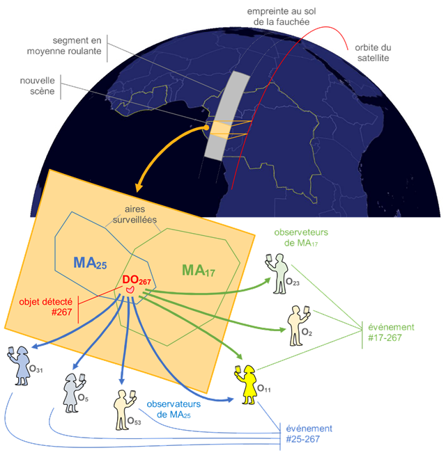
Fig. 3 - FLEGT Watch’s alert system explanatory diagram
FLEGT Watch App - Manage field missions
Observers can create a mission whose target will be the deforestation event detected by FLEGT Watch or a location that he (or she) will define. Maps and images can be downloaded to the smartphone to help guide the observer in the field even without an Internet connection.
In the field, users can make observations : images / videos / interviews. These observations are automatically geocoded and annotated with the day and time of acquisition. User is invited to add a title and a description to the observation.
Once back from the mission, observers can share all or part of the observations with their community. It is then possible to generate mission reports. See for example the mission reports in Libreville (Gabon) or Yangambi (DRC).
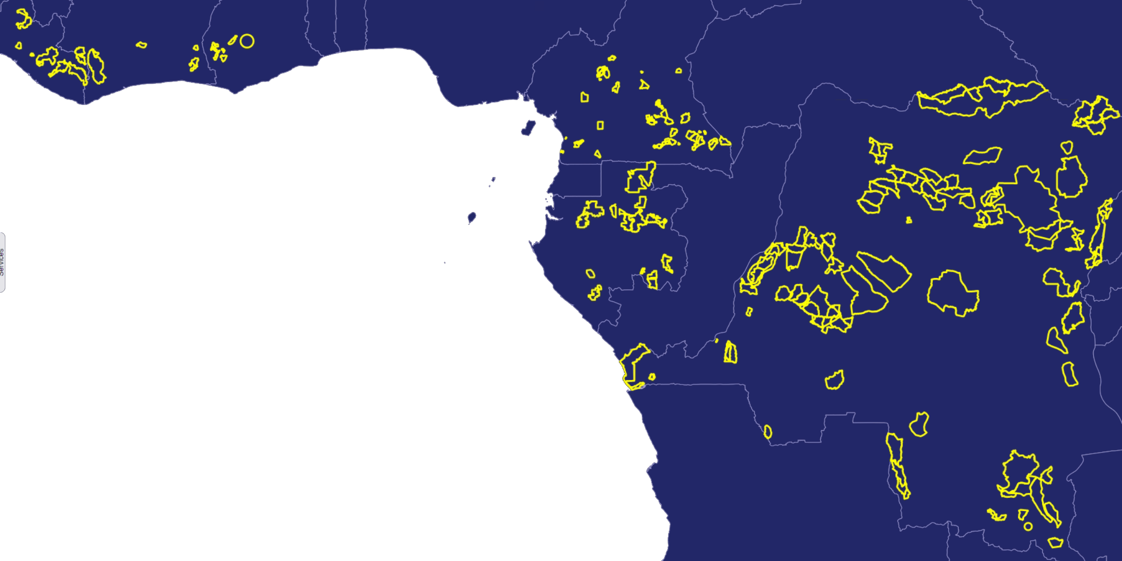
FLEGT Watch in numbers
The supervised areas are numerous and very large :
|
country |
number of monitored areas |
total surface area (in ha) |
|
Ghana |
6 |
373 309 |
|
Ivory Coast |
8 |
847 510 |
|
Liberia |
9 |
925 674 |
|
Cameroon |
46 |
1 420 930 |
|
Gabon |
25 |
2 627 346 |
|
Democratic
Republic of Congo
|
92 |
39 072 426 |
FLEGT Watch currently has a total of 186 monitored areas, comprising no less than 45 million hectares of land.
Resources and useful links
|
Description |
link(s) |
|
FLEGT Watch Web |
FlegtWatch |
|
FLEGT Watch App - tutorial for installing and using the mobile application |
|
|
FLEGT Watch App - Download link |
app.apk |
|
|
|
|
Mission Kinshasa (RDC)
17 to 20 May 2021
|
|
|
|
PDF |
|
|
HTML - PDF - KML |
|
|
|
|
Mission Yangambi (DRC)
February 24 to 29, 2020
|
|
-
Remote sensing training material
|
PDF |
|
|
PDF |
|
|
HTML - PDF - KML |
|
|
|
|
Mission Libreville (Gabon)
October 3 to 4, 2019
|
|
-
Preparation, training and mission
|
PDF |
|
|
PDF |
|
|
PDF |
|
|
HTML- PDF- KML |
|
|
|
|
Mission Douala (Cameroon)
October 3 to 4, 2019
|
-
Training support to the private forestry sector
|
PDF |
|
|
|
|
Mission Kisangani (RDC)
July 29 to August 2, 2019
|
|
-
Preparation, training and mission
|
PDF |
|
|
PDF |
|
|
HTML - PDF- KML |
|
|
|
|
Mission Kumasi (Ghana)
April 8 to 11, 2019
|
|
-
Preparation, training and mission
|
PDF |
|
|
PDF |
|
|
HTML - PDF - KML |
|
|
|
Some of the many successes
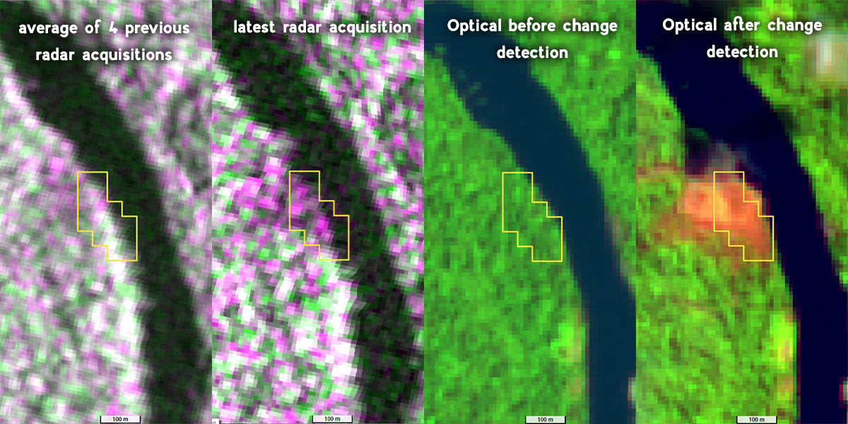
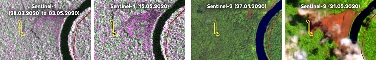
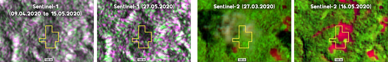
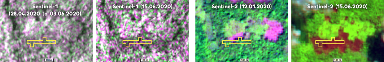
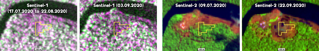
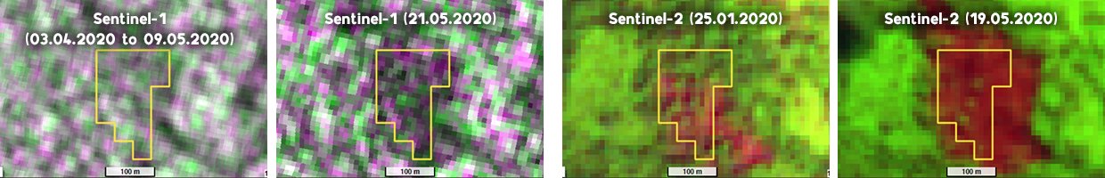
Examples below show, in the two left columns, the Sentinel-1 radar views before and after the deforestation event automatically detected by FLEGT Watch. The date of the event is given in the second radar image (e.g. 15.05.2020 in figure 4).
To help confirm the event, the two views on the right correspond to Sentinel-2 optical data observed at the same location with acquisition dates framing the date of the event.
By clicking on the hyperlook in the figure caption, the images can be interactively manipulated in your web browser. The layer stack can be displayed by activating the small icon with 3 horizontal lines ( ) at the far right of the display area.
Fig. 4 - Deforestation detected in DRC (hyperlook)
Fig. 5 - Deforestation detected in Cameroon (hyperlook)
Fig. 6 - Deforestation detected in Cameroon (hyperlook)
Fig. 7 - Deforestation detected in DRC (hyperlook)
Fig. 8 - Deforestation detected in DRC (hyperlook)
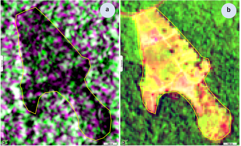
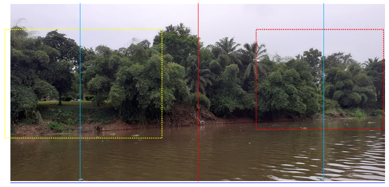
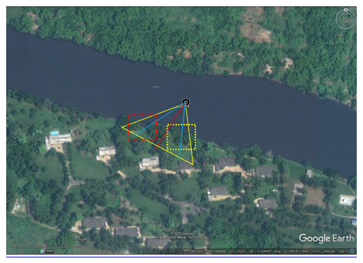
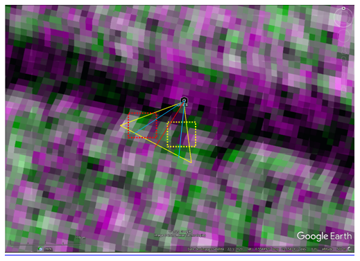
Deforestation observed in the field
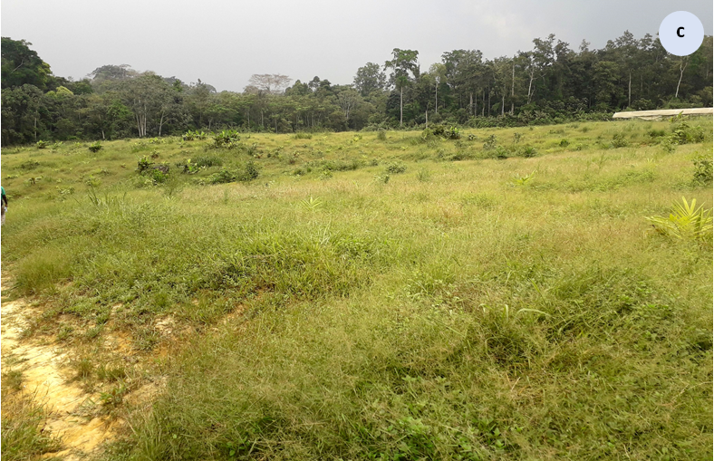
Field missions make it possible to link satellite views to in-situ observations. During the training held from January 27 to 31, 2020 with Brainforest in Libreville (Gabon), a field mission was organized on January 30 to understand the deforestation observed by satellites in two phases : June-July 2017 and then November-December 2018. At the end of this second phase no less than 33 hectares of forests were removed. A field visit confirms this deforestation and finds that it could have been avoided since the very sandy soils do not retain rain. Agricultural experiments all seem to be unsuccessful.
Fig. 9 - Sentinel-1 radar of December 23, 2018 (a) and Sentinel-2 optical of April 17, 2019 (b). Field view of January 30, 2020 (c).
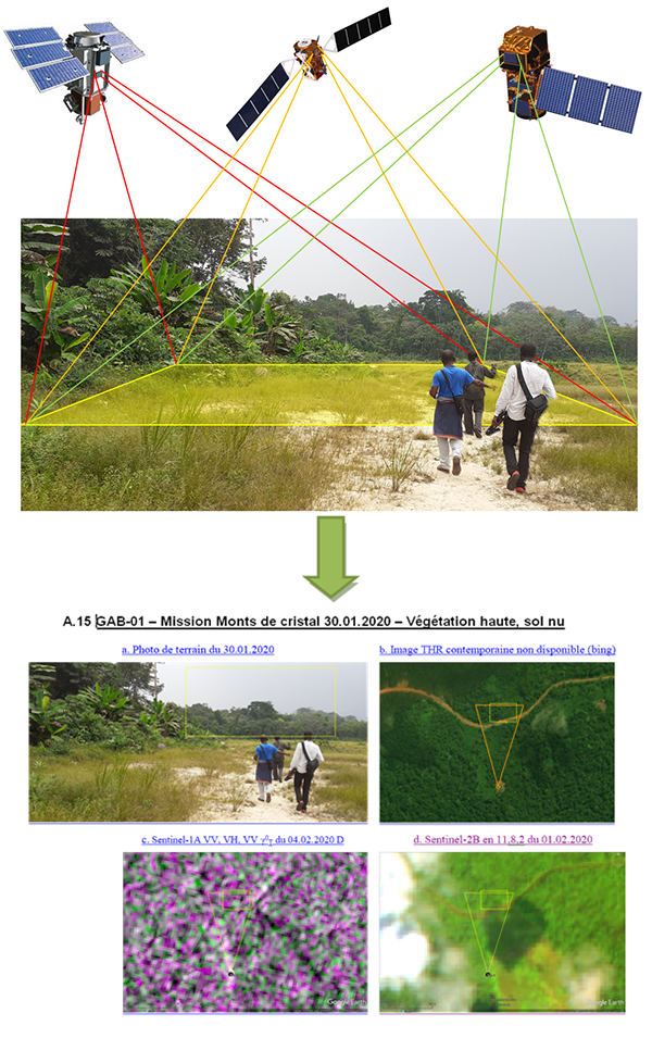
Photo-interpretation atlas
Visioterra maintains an atlas to better understand the radar signal.
This atlas provides various examples (sheets) of field photos, each associated with its equivalent seen from space in very high resolution (VHR at a ground sampling distance of less than 1 metre), in radar imagery (Sentinel-1) and in optical imagery (Sentinel-2), both acquired in high resolution (HR at a ground sampling distance of 10 metres).
Fig. 10 - From field observations to satellite observations.
Sheet below is extracted from the atlas and show a mixture of high vegetation, low vegetation, bare soils and houses.
COD-09 – Mission Yangambi 24.02.2020 – High vegetation, urban
|
a. Field photo of 24.02.2020 |
b. VHR image of January 2020 |
 |
 |
|
c. Sentinel-1A (VV,VH,VV) of 24.02.2020 |
d. Sentinel-2A (11,8,2) of 28.02.2020 |
 |
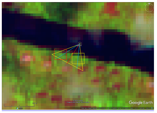 |
Fig. 11 - COD-09 – Mission Yangambi 24.02.2020 – High vegetation and urban
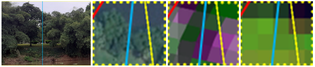
Case 1 - Trees, low vegetation
Fig. 12 – COD-09 – Trees, low vegetation.
A greater depolarization of the VH backscattered signal is observed above at the level of the left tree than at the level of the right tree (on the radar) despite the fact that they appear to be of the same species.
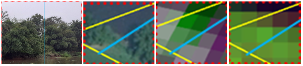
Case 2 - Trees, low vegetation
Fig. 13 – COD-09 – Trees, low vegetation.
A greater depolarization of the VH radar signal is observed above in the low vegetation zone than at the level of very dense trees.