VisioTerra

Founded in May 2004, VisioTerra is an independent French company specialized in scientific consulting for Earth observation.

VtWeb The World at your fingertips

VisioTerra has developed VtWeb to allow citizens and scientists to access, process, display, share and export a wide range of free data available on the Web: Earth observation / meteorological / climate / biogeophysical data.
The objective is to allow users to access all these data very easily and to discover correlations between different domains.

References and projects

VisioTerra has carried out numerous projects in the framework of various partnerships.

From satellites to users

Through VtWeb, its derivative platforms and framework, VisioTerra enables any citizen to visualize, analyze and share Earth observation data and models. 

Whether you are a neophyte, a researcher or a developer, VisioTerra has developed powerful and flexible Earth observation tools that you can try for free right now.

Earth Observation Engineering

Thanks to the design of platforms such as MISBAR or CAFWS, VisioTerra makes it possible to use earth observation data for operations such as monitoring agriculture or deforestation.

Our Missions

At the service of the Institutions and the Communities

Access online services

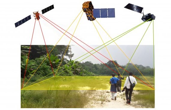
VisioTerra helps citizens of developing countries to assemble their geoservices platforms for agriculture, water management, deforestation, environment or land degradation monitoring... Tools are available for monitoring and evaluation with dashboards, periodic bulletins, early warnings... from plot to region.

Train and support users

Holder of the "Copernicus Academy" label, VisioTerra staff teaches in universities and institutes, intervenes at scientific events, organizes training and capacity building workshops, carries out field missions, supports users in accessing Earth observation data and models, process, interpret and share them.

Fighting the digital divide

Aware of the difficulties of accessing the Internet in many regions of the world, VisioTerra engineers have developed techniques for processing terabytes of data from simple smartphones. The product of geoservices is an "information thread" that the user configures remotely, comments and shares with his community in a collaborative mode.

At the service of data providers

Access and enhance their data

VisioTerra helps space agencies to make their data easily accessible, process them on the fly, analyze them, restore them, calculate indicators, mix dates, offer time-series ... "Stories" are regularly published which show the complementarity of the different instruments and numerous examples of applications in touch with current events.

Develop service relays from their data

VisioTerra develops geoservice platforms capable of processing data on the fly just in the area of ​​interest and at the scale required by the user. Orthorectification, calibration, correction of the effects of relief, multi-date combinations ... treatments spare the agencies the systematic or on-demand production of heavy data.

Maintain a technological advance

Located on the Paris-Est Marne-la-Vallée Campus, VisioTerra collaborates with education and research institutes, supervises doctoral students and actively participates in R&D projects. Several concepts have been invented and implemented such as "Data Processing Relay (DPR)", "hyperlooks", the "POF-ML" language, the "RCSE" radar filter, "multi-scale signatures". .